


MODIS Airborne Simulator (MAS)
CAMPAIGN SUMMARY INFORMATION
|
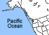
Arctic Radiation Measurment in Column: Atmosphere-Surface Dates: 02 June - 16 June 1995 Location: Alaska: (Brooks Range, North Slope, Beaufort Sea) Principal Investigators: Dr. Michael King (NASA GSFC) Objective: Detect and differentiate between clouds, ice, and snow. |
||||||||||||||||||||||||
|
Processing Information Flights Processed: 9 of 9 Total Flight Tracks: 120 Total Scanlines: 659790 Level-1B Version: #09 Calibration Type: Final Calibration Version: ARMCAS_King 1.1 Temperature Adjustment: 35C Status: Level-1B Data in HDF format is available. |
||||||||||||||||||||||||
|
Spectral Information Spectral Band Configuration Spectral Response Function Table | ||||||||||||||||||||||||
|
Level-1B Data Distribution Level 1 / Atmosphere Archive and Distribution System (LAADS) NASA Distributive Active Archive Centers (DAACs) |
||||||||||||||||||||||||
|
||||||||||||||||||||||||
|
Related Web Sites NASA Airborne Science Program |
||||||||||||||||||||||||
 Flight: 95-112
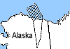 Flight: 95-113
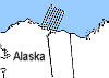 Flight: 95-115
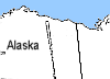 Flight: 95-116
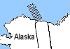 Flight: 95-117
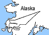 Flight: 95-118
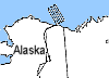 Flight: 95-119
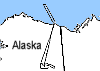 Flight: 95-120
 Flight: 95-121
ARMCAS


| Sample Imagery |
| Click image for full resolution |
|
Flight: 95-115, Track #01 Brooks Range, AK |


|
|
R: 2.14µm G: 1.68µm B: 0.65µm |
- NASA Official: Matt Fladeland
- Project Manager: James Jacobson
- Website Editor: Eric Fraim
- Last Updated: March 21, 2024


