


CAMPAIGN SUMMARY INFORMATION
|
HyspIRI Hawaii 2017 Dates: 17 January - 3 March, 2017 Location: Hawaiian Islands Principal Investigators: Hook / Green (JPL) Aircraft: NASA 806 ER-2 (Armstrong Flight Research Center) Additional Sensors: AVIRIS Objective: NASAs Hyperspectral Infrared Imager (HyspIRI) orbital mission will observe the worlds ecosystems and provide critical information on natural disasters such as volcanoes, wildfires, and drought. It will provide a benchmark on the state of the worlds ecosystems against which future changes can be assessed, as the instruments will be capable of identifying vegetation type and health. The HyspIRI Airborne Campaign is a multi-year effort to collect seasonal VIS-SWIR and TIR airborne scanner data using both AVIRIS and MASTER remote sensing instruments aboard the ER-2 high-altitude platform. |
||||||||||||||||||||||||||||||||||||||||||||||||||||
|
Processing Information Flights Processed: 18 Total Flight Tracks: 151 Total Scanlines: 564,558 Level-1B Version: 1 / 2 / 3 / 4 (see individual missions for details) Calibration Version: 1 Status: Level-1B Data available |
||||||||||||||||||||||||||||||||||||||||||||||||||||
|
MASTER Spectral Information Spectral Band Configuration Spectral Response Function Table |
||||||||||||||||||||||||||||||||||||||||||||||||||||
|
Related Web Sites HyspIRI Airborne Mission List NASA Airborne Science Program Airborne Visible-Infrared Imaging Spectrometer (AVIRIS) |
||||||||||||||||||||||||||||||||||||||||||||||||||||
|
||||||||||||||||||||||||||||||||||||||||||||||||||||
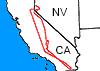 Flight: 17-606-00
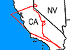 Flight: 17-607-00
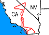 Flight: 17-609-00
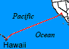 Flight: 17-610-00
 Flight: 17-611-00
 Flight: 17-612-00
 Flight: 17-613-00
 Flight: 17-614-00
 Flight: 17-616-00
 Flight: 17-618-00
 Flight: 17-619-00
 Flight: 17-620-00
 Flight: 17-621-00
 Flight: 17-623-00
 Flight: 17-624-00
 Flight: 17-625-00
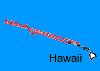 Flight: 17-626-00
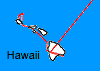 Flight: 17-627-00