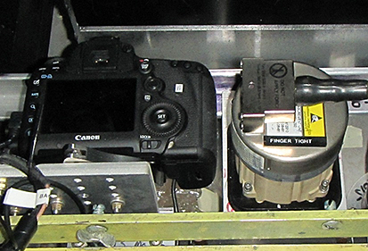
DIGITAL MAPPING SYSTEM
The Digital Mapping System (DMS) is an airborne digital camera that acquires high resolution natural color and panchromatic imagery from low and medium altitude research aircraft. Data acquired by DMS are used by a variety of scientific programs to monitor variation in environmental conditions, assess global change, and respond to natural disasters.

PHOTOGRAMMETRY
|
Cross-Track Frame Orientation |
|||||||
| Pixel Dimensions: 5616 x 3744 (across-track / along-track) | |||||||
| Array Dimensions: 35mm x 23mm (width / length) | |||||||
| Altitude (feet) | Focal Length (millimeters) | Cross-track FOV (degrees) | Along-track FOV (degrees) | Nadir Pixel Resolution (meters) | Swath Width (meters) | Swath Length (meters) | Area (miles²) |
| 1500 | 28 | 64.0 | 45.2 | 0.10 | 571 | 381 | 0.22 |
| 40000 | 28 | 64.0 | 45.2 | 2.71 | 15239 | 10160 | 154.82 |
| 40000 | 85 | 23.3 | 15.6 | 0.89 | 5020 | 3347 | 16.80 |
|
Along-Track Frame Orientation |
|||||||
| Pixel Dimensions: 3744 x 5616 (across-track / along-track) | |||||||
| Array Dimensions: 23mm x 35mm (width / length) | |||||||
| Altitude (AGL, feet) | Focal Length (millimeters) | Cross-track FOV (degrees) | Along-track FOV (degrees) | Nadir Pixel Resolution (meters) | Swath Width (meters) | Swath Length (meters) | Area (miles²) |
| 1500 | 28 | 45.2 | 64.0 | 0.10 | 381 | 571 | 0.22 |
| 40000 | 28 | 45.2 | 64.0 | 2.71 | 10158 | 15237 | 154.78 |
| 40000 | 85 | 15.6 | 23.3 | 0.89 | 3346 | 5019 | 16.80 |


