Flight: 25-965-00
Date: 25 Jul 2025
Aircraft: NASA ER-2 #809
Campaign: GEMx 2025
Flight Location: Northeastern Arizona (AZ05)
Principal Investigators: Kokaly (USGS)
Additional Sensors: AVIRIS-C / AVIRIS-5
|
Data Evaluation
Overall quality is good
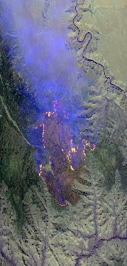
Dragon Bravo Fire @ 2102Z
|
Processing Information
Level-1B Data in HDF format is available
Flight Line Summary
Spectral Band Configuration
Spectral Response Function Table
Spectral Response Function (text)
|
Browse Imagery
Flight Tracks: 9
Scanlines: 81028
|
Browse Imagery Table
|
Click a Flight Track number to view a quicklook image
Lat/Lon ranges are for the BEG-END scanline nadir pixels
|
Flight
Track |
Time Span
(UTC) |
Heading
(Deg) |
Lat Range
(Deg N) |
Lon Range
(Deg W) |
Length
(Scanlines) |
Altitude
(Meters) |
| 1 |
16:34 - 17:08 |
91.0 |
34.561 - 34.492 |
113.133 - 108.699 |
12868 |
20313 |
| 2 |
17:22 - 17:46 |
0.6 |
34.428 - 37.094 |
110.392 - 110.389 |
8682 |
20321 |
| 3 |
17:50 - 18:15 |
176.9 |
37.226 - 34.457 |
110.292 - 110.290 |
9502 |
20291 |
| 4 |
18:20 - 18:44 |
1.9 |
34.319 - 37.098 |
110.191 - 110.189 |
9097 |
20295 |
| 5 |
18:48 - 19:14 |
176.9 |
37.253 - 34.393 |
110.092 - 110.092 |
9745 |
20238 |
| 6 |
19:18 - 19:44 |
0.8 |
34.251 - 37.095 |
109.993 - 109.990 |
9438 |
20308 |
| 7 |
19:48 - 20:13 |
178.7 |
37.245 - 34.455 |
109.892 - 109.892 |
9321 |
20259 |
| 8 |
20:17 - 20:42 |
0.0 |
34.293 - 37.094 |
109.794 - 109.792 |
9464 |
20286 |
| 9 |
20:57 - 21:04 |
217.1 |
36.647 - 35.953 |
111.699 - 112.344 |
2911 |
20270 |
|


