


MODIS Airborne Simulator (MAS)
EMAS INSTRUMENT OVERVIEW
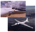 The Enhanced MODIS
Airborne Simulator (eMAS) is a modified Daedalus Wildfire
scanning spectrometer which flies on a NASA
ER-2 high altitude research aircraft and provides
spectral information similar to that which is
provided by the Moderate Resolution Imaging
Spectroradiometer (MODIS) aboard the NASA TERRA satellite, The Enhanced MODIS
Airborne Simulator (eMAS) is a modified Daedalus Wildfire
scanning spectrometer which flies on a NASA
ER-2 high altitude research aircraft and provides
spectral information similar to that which is
provided by the Moderate Resolution Imaging
Spectroradiometer (MODIS) aboard the NASA TERRA satellite,
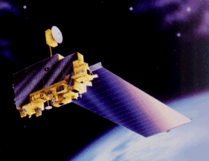 successfully launched on December 18, 1999.
The principal scientific investigator for the MAS is Dr. Steven Platnick. The Wildfire Spectrometer was delivered to NASA Ames Research Center in April 1991. A single visible channel was added and several spectral channels in the infrared port were altered to configure the instrument for the FIRE Cirrus-II experiment. In January 1992 the modified Wildfire was then further modified to become MAS. Beginning in June of 1992, the MAS has been flown in a series of experiments that have lasted on average 2 to 8 weeks, with anywhere from 5 to 15 flights carried during each experiment. The MAS spectrometer acquires high spatial resolution imagery in the range of 0.55 to 14.3 microns. A total of 50 spectral bands are available in this range. Pre-1995 the digitizer was configured for each mission to record a pre-selected group of 12 bands during the flight. For most of these missions the digitizer was configured to record four 10-bit channels and seven 8-bit channels. A 50-channel digitizer which records all 50 spectral bands at 12 bit resolution became operational in January 1995. The MAS spectrometer is mated to a scanner sub-assembly which collects image data with an IFOV of 2.5 mrad, giving a ground resolution of 50 meters from 20000 meters altitude, and a cross track scan width of 85.92 degrees.
|
||||||||||||||||||||||||||||||||||||||||||||

Specifications


Earth Scene Imagery

These sample images represent the enormous repository of data from various campaigns collected over the past two decades.
- NASA Official: Matt Fladeland
- Project Manager: James Jacobson
- Website Editor: Eric Fraim
- Last Updated: March 21, 2024


