


MODIS Airborne Simulator (eMAS)
NASA'S EARTH OBSERVER MAGAZINE ARTICLE
Introduction
 The MODIS Airborne Simulator (MAS) continues to evolve to
meet scientific requirements for airborne remote sensing
of clouds, aerosols, water vapor and land. During its
development, MAS has flown periodically on both national
and international campaigns. These missions have provided
valuable experimental data to determine the capability of
narrow bandpass channels in examining the Earth's
atmosphere and in performing scientific research. These
early indications suggest that MAS will successfully
fulfill its goal, which is to aid in defining algorithms
and build an understanding of the ability of MODIS to
remotely sense atmospheric conditions for assessing
global change.
The MODIS Airborne Simulator (MAS) continues to evolve to
meet scientific requirements for airborne remote sensing
of clouds, aerosols, water vapor and land. During its
development, MAS has flown periodically on both national
and international campaigns. These missions have provided
valuable experimental data to determine the capability of
narrow bandpass channels in examining the Earth's
atmosphere and in performing scientific research. These
early indications suggest that MAS will successfully
fulfill its goal, which is to aid in defining algorithms
and build an understanding of the ability of MODIS to
remotely sense atmospheric conditions for assessing
global change.
History
Prior to 1991, the MODIS Atmosphere Discipline Group performed atmospheric investigations with data from the Multispectral Cloud Radiometer (MCR) and the Multispectral Atmospheric Mapping Sensor (MAMS). These instruments have both flown on the NASA ER-2, a high- altitude research aircraft based out of Ames Research Center. By 1991 the limited channel capability and problematic performance of the MCR and MAMS could not be altered to fit the needs of the users. A study of the latest scanners was conducted to determine which would be appropriate for conducting MODIS simulations. Funding and design schedules were also considered. Of all the sensors reviewed, the Wildfire infrared imaging spectrometer was found to be the most adaptable to the science requirements. It possessed fifty narrow bandwidth channels, a blackbody calibrator system and could mount in the wing pod of the ER-2. It was under development and due to be operational in 1991. The principle investigator of WILDFIRE (Jim Brass) and John Arvesen (Branch Chief of the High Altitude Missions Branch at Ames) were amenable to our proposal to modify the instrument immediately after development to meet the schedule for the First ISCCP (International Satellite Cloud Climatology Project) Regional Experiment (FIRE) cirrus campaign, to be conducted near Coffeyville, KS during November 1991. This was to be the first MAS field deployment. Ames' cooperation was a major factor in the selection and scheduling.
An Overview of WILDFIRE
In 1987, Dedalus Enterprises, Inc., began developing the WILDFIRE infrared imaging spectrometer as a shortwave-infrared, near-infrared and infrared spectrometer to monitor gases carried into the upper atmosphere, nutrient transport phenomena, and the intensity and size of forest fires. The instrument is a 50 channel cross track scanning spectrometer consisting of 4 spectrometer and detector subassemblies or ports with linear array detectors (InGaAs, InSb, InSb, and HgCdTe). The wavelength range of the WILDFIRE spectrometer was 1.17-12.4 um. This spectrometer is joined to a scanner subassembly that collects radiometric imaging data with the following characteristics:
- Spatial resolution of 2.5 mrad, corresponding to a ground resolution of 45 m at nadir from a nominal ER-2 altitude of 18 km,
- Cross track scan of +-43 degree, equivalent to a swath width of 34 km with 716 pixels per scan,
- Scan rate of 375 rpm (6.25 Hz).
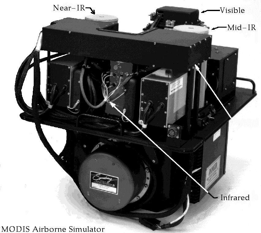
A photograph of the WILDFIRE spectrometer mated to the scanner subassembly is shown above. There are up to 16 channel outputs dispersed from each of the four detector assemblies.
With inputs from the MODIS, CERES and FIRE II Science Teams, the opportunity arose to modify this very capable system to more fully meet the needs of the earth science research community.
Converting WILDFIRE into MAS
Converting the WILDFIRE infrared imaging spectrometer into a MODIS Airborne Simulator (MAS) was a gradual metamorphosis. First, there was the FIRE II configuration, focused on cirrus clouds in the central U.S. and the Gulf of Mexico. Less than 6 months later the upgraded MAS was deployed to the Azores, Portugal as part of the Atlantic Stratocumulus Transition Experiment (ASTEX), where the focus was on marine stratocumulus clouds over the eastern Atlantic Ocean. The MAS is currently deployed to Townsville, Australia as part of the Tropical Oceans- Global Atmosphere Coupled Ocean-Atmosphere Response Experiment (TOGA-COARE), focused on high-altitude cirrus clouds and convective cloud systems of the western Pacific. These changes in WILDFIRE have primarily been driven by the need to increase the performance, reduce the saturation temperature in the thermal infrared, and to extend the wavelength coverage in the visible as well as the thermal infrared for the remote sensing of clouds, aerosols, and water vapor, and finally to increase the number of bands that have corresponding channels on MODIS. These changes were considered and prioritized in light of available resources and flight schedules, and were conducted between field campaigns so that the MAS was able to complement other sensors (e.g., lidar, infrared sensors) needed to support atmospheric missions.
The MAS configuration for the FIRE II campaign differed from the original WILDFIRE configuration in that one SWIR set of channels was replaced with a single 0.68-um channel and several other spectrometer channels were readjusted. The channels of the MAS for the FIRE II campaign are given in Table 1. Eleven flights were conducted over the FIRE ground site at Coffeyville, KS and/or the Gulf of Mexico. The aircraft data system could only handle a limited number of channels, so eleven of the most significant ones were selected. Of these, seven channels were recorded at 8 bits, while the remaining four channels were recorded at 10 bits. These flights, coordinated with the NCAR Sabreliner, University of North Dakota Citation, and NOAA 11 and Landsat-4 satellites, were all successful. Two thermal infrared channels--3.75 and 4.50 um--were noisier than desired, thereby limiting their measurement capability. Subsequent development has improved the sensitivity and accuracy in this wavelength region.
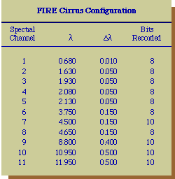 Table 1
Paul Menzel (NOAA/NESDIS, University of Wisconsin) examined the engineering flight data and set the gains of the instrument for the first research flights. He subsequently processed the FIRE II data and converted it to the spatial resolution of MODIS. In this way he was able to reduce the instrument noise as well as simulate the scene characteristics likely to be obtained using MODIS. The onboard thermal blackbodies and the ground-based visible and near-infrared calibration obtained by viewing the Goddard integrating hemisphere were used to calibrate the data. Finally, cold-chamber tests were conducted at Ames Research Center to assess the effect of temperature on the visible and near-infrared calibration coefficients, since the ER-2 flies at a much colder temperature than the surface where the ground-based calibration was performed. All data were processed post-flight by the MODIS Science Data Support Team, thereby providing calibrated MAS radiances for every pixel on every scanline and geolocation data (latitude, longitude, solar zenith angle, zenith and azimuth angles of the observations) for every tenth pixel on every scanline. These output data files also contain the spectral channels that were recorded, as well as the calibration coefficients and navigation data (altitude, heading, etc.), and are available in netCDF format on Exabyte 8500 tapes through the NASA Climate Data System (NCDS) at the Goddard DAAC (now known as DAAC/Climate).
Conversion for ASTEX
The MAS was returned to Dedalus Enterprises for further modification in January 1992. At that time the visible and thermal detector/spectrometer ports were to be completed. The single visible silicon (Si) detector was replaced by a nine-element visible and shortwave infrared linear array detector. The thermal (HgCdTe) detector was also replaced. However, due to problems with the detector and the thermal lens, the modifications were incomplete when MAS was delivered for the ASTEX campaign in May. A gain change due to the hostile high altitude environment, which was observed during FIRE II cirrus campaign, and the aircraft 400-Hz interference noise on the thermal detector, were further reduced. The fully-configured MAS for ASTEX was a 50-channel spectrometer with 19 channels having spectral characteristics similar to those of MODIS. Again, the aircraft data system could only handle eleven channels, with the ones selected for this deployment listed in Table 2.
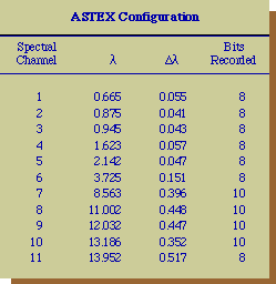 Table 2
The ASTEX campaign was conducted from Terceira, Azores during June 1- 28, and provided many multispectral images of marine stratocumulus in the eastern Atlantic. The instrument with the new thermal and VIS-SWIR detector systems operated nominally. Eleven ER-2 flights were conducted during this campaign. The MAS operated successfully but the data system only recorded nine of these flights. Noise was observed in the newly- installed CO2 slicing (13.19 and 13.95 um) channels. These channels were noisy for several reasons, a thermal lens coating had begun to degrade, and the detectors were picking up radio interference noise from the unsheilded ER-2 pod heater-blower motor.
In-Flight Performance
On June 17 the ER-2 flew a coordinated mission in which the NASA ER-2 flew above and the University of Washington C-131A aircraft flew within an extensive marine stratocumulus cloud layer located approximately 1380 km west of Lisbon. This mission also included coordination with the SPOT satellite. Figure 1 illustrates MAS images of reflected solar radiation at two spectral channels (0.665 and 2.142 um), where the images have been converted from calibrated radiances to reflection function, formed from a ratio of the reflected radiance and the incident solar zenith angle and solar flux. In both of these images, the aircraft was flying from top to bottom down the center of these images with the MAS scanning clockwise. These images represent reflectances over an 85 km x 35 km of the Atlantic, with a clearly defined demarcation between marine stratocumulus (upper portion of the image) and continental stratocumulus (lower portion). In spite of the great distance from the European mainland, there was a large aerosol outbreak that led to clouds with larger numbers of small droplets in the continental clouds. These images have been used to derive the cloud optical thickness and effective droplet radius (not shown), and will provide many opportunities to test and validate remote sensing algorithms for MODIS, CERES and ASTER.
 Figure
1. Images of the reflection function of clouds at
0.665 and 2.142 um, derived from 2600 scan lines of MAS
data on June 17, 1992. These data were acquired over
marine stratocumulus clouds some 1380 km west of Lisbon,
near the Azores.
Figure
1. Images of the reflection function of clouds at
0.665 and 2.142 um, derived from 2600 scan lines of MAS
data on June 17, 1992. These data were acquired over
marine stratocumulus clouds some 1380 km west of Lisbon,
near the Azores.
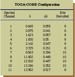 Table 3
System Upgrades
Following ASTEX, the CO2 slicing (13.19-14.30 um) channels will be modified to increase the radiometric sensitivity. The grating and detector will be modified to improve the transmission and consequently the sensitivity of those channels. Because the original HgCdTe thermal detector has degraded, a more reliable detector was selected as its replacement.
The instrument configuration for the upcoming TOGA-COARE and Central Equatorial Pacific Experiment (CEPEX) campaigns is identical to that of ASTEX, except that a wide-band thermal lens has been selected to replace the lens used previously. This serves to extend the useful spectral range to 14.3 um. The channels to be recorded for TOGA-COARE, shown in Table 3, are somewhat different than those recorded for ASTEX. Replacing the wide bandpass thermal lens and shielding the MAS from the pod heater and blower system has improved the signal-to-noise ratio for the 8.9 - 13.8 um channels. The new detector and its discrete cold filter will be installed after the instrument returns from the TOGA-COARE field campaign. The cycle of development and field deployments has continuously improved the MAS performance and the resulting data quality.
Future Modifications
A 50 channel, 16-bit data system is currently being developed for the MAS. This system, when completed in the winter of 1993, will enable the MAS to record all 50 channels at 16-bit digitization, thereby allowing 12 bits of noise free data with a dynamic gain adjustment range of 16. With these modifications, it is expected that the MAS will meet the needs for atmospheric, land and ocean remote sensing applications. In addition to the CERES and MODIS science teams, MAS will serve a broader science community for many years to come.
Acknowledgments
The development of MAS has been the joint effort of many people at Goddard Space Flight Center (Ken Brown, Liam Gumley, Tom Arnold), Ames Research Center (Pat Grant, Jim Brass, Ted Hildum, John Arvesen), the University of Wisconsin (Paul Menzel, Chris Moeller), and Dedalus Enterprises (Fred Osterwisch, Steve Cech).
Back to Top

Reference


Earth Scene Imagery

These sample images represent the enormous repository of data from various campaigns collected over the past two decades.
- NASA Official: Matt Fladeland
- Project Manager: James Jacobson
- Website Editor: Eric Fraim
- Last Updated: March 21, 2024


