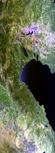
Flight: 25-960-00
Date: 15 Jul 2025
Aircraft: NASA ER-2 #809
Campaign: WDTS Spring 2025
Flight Location: Lake Tahoe / Soda Straw, CA
Principal Investigators: Hook / Green (JPL)
Additional Sensors: AVIRIS-C / AVIRIS-5
|
Data Evaluation
Overall quality is good
|
Processing Information
Level-1B Data in HDF format is available
Flight Line Summary
Spectral Band Configuration
Spectral Response Function Table
Spectral Response Function (text)
|
Browse Imagery
Flight Tracks: 12
Scanlines: 63053
|
Browse Imagery Table
|
Click a Flight Track number to view a quicklook image
Lat/Lon ranges are for the BEG-END scanline nadir pixels
|
Flight
Track |
Time Span
(UTC) |
Heading
(Deg) |
Lat Range
(Deg N) |
Lon Range
(Deg W) |
Length
(Scanlines) |
Altitude
(Meters) |
| 1 |
16:55 - 17:06 |
220.3 |
38.840 - 37.892 |
119.412 - 120.608 |
4285 |
20357 |
| 2 |
17:09 - 17:23 |
47.0 |
37.973 - 39.010 |
120.803 - 119.499 |
5008 |
20346 |
| 3 |
17:26 - 17:38 |
219.0 |
39.075 - 38.112 |
119.712 - 120.915 |
4340 |
20341 |
| 4 |
17:41 - 17:54 |
51.0 |
37.943 - 38.961 |
120.718 - 119.411 |
4895 |
20350 |
| 5 |
17:57 - 18:09 |
219.4 |
39.012 - 38.036 |
119.638 - 120.862 |
4440 |
20342 |
| 6 |
18:13 - 18:26 |
47.8 |
38.191 - 39.196 |
120.973 - 119.708 |
4849 |
20338 |
| 7 |
18:31 - 18:43 |
221.9 |
39.274 - 38.285 |
119.910 - 121.141 |
4479 |
20343 |
| 8 |
18:46 - 18:58 |
47.8 |
38.396 - 39.400 |
121.313 - 120.053 |
4827 |
20360 |
| 9 |
19:02 - 19:14 |
217.8 |
39.191 - 38.239 |
119.869 - 121.051 |
4303 |
20340 |
| 10 |
19:17 - 19:29 |
47.0 |
38.365 - 39.349 |
121.194 - 119.965 |
4626 |
20341 |
| 11 |
19:33 - 19:44 |
219.1 |
39.419 - 38.476 |
120.177 - 121.353 |
4286 |
20337 |
| 12 |
20:04 - 20:38 |
186.7 |
38.120 - 34.373 |
119.052 - 119.926 |
12715 |
20320 |
|


