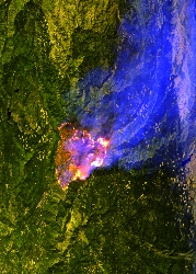
Flight: 22-630-00
Date: 08 Sep 2022
Aircraft: ER-2 #806
Deployment: WDTS Summer 2022
Flight Location: Lake Tahoe / Soda Straw / Mosquito Fire, CA
Principal Investigators: Hook / Green (JPL)
Additional Sensors: AVIRIS / PICARD / HyTES / HySpex
|
Data Evaluation
Overall quality is good
|
Processing Information
Level-1B Data in HDF format is available
Flight Line Summary
Spectral Band Configuration
Spectral Response Function Table
Spectral Response Function (text)
|
Browse Imagery
Flight Tracks: 12
Scanlines: 67770
|
Browse Imagery Table
|
Click a Flight Track number to view a quicklook image
Lat/Lon ranges are for the BEG-END scanline nadir pixels
|
Flight
Track |
Time Span
(UTC) |
Heading
(Deg) |
Lat Range
(Deg N) |
Lon Range
(Deg W) |
Length
(Scanlines) |
Altitude
(Meters) |
| 1 |
17:25 - 17:39 |
229.9 |
38.932 - 37.893 |
119.303 - 120.607 |
4932 |
20234 |
| 2 |
17:43 - 17:56 |
39.9 |
37.853 - 38.934 |
120.801 - 119.448 |
5054 |
20192 |
| 3 |
18:01 - 18:15 |
226.4 |
39.101 - 38.017 |
119.383 - 120.742 |
5139 |
20190 |
| 4 |
18:19 - 18:32 |
38.8 |
37.970 - 39.048 |
120.940 - 119.598 |
4971 |
20199 |
| 5 |
18:36 - 18:50 |
223.7 |
39.237 - 38.132 |
119.505 - 120.890 |
5201 |
20196 |
| 6 |
18:54 - 19:08 |
40.5 |
38.085 - 39.164 |
121.083 - 119.750 |
5009 |
20181 |
| 7 |
19:12 - 19:25 |
225.8 |
39.340 - 38.248 |
119.674 - 121.041 |
5103 |
20192 |
| 8 |
19:30 - 19:43 |
40.4 |
38.184 - 39.278 |
121.268 - 119.903 |
5142 |
20175 |
| 9 |
19:47 - 20:00 |
225.1 |
39.451 - 38.364 |
119.832 - 121.193 |
4953 |
20181 |
| 10 |
20:04 - 20:18 |
38.4 |
38.295 - 39.397 |
121.416 - 120.057 |
5236 |
20180 |
| 11 |
20:22 - 20:35 |
226.0 |
39.561 - 38.481 |
120.004 - 121.348 |
4836 |
20185 |
| 12 |
20:54 - 21:26 |
189.9 |
38.167 - 34.381 |
119.030 - 119.924 |
12194 |
20176 |
|


