|
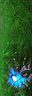
Sample Image

30 July 1996
Track 03


Snow (in blue) and cloud covered summit of Mount Rainier, Washington
R: 2.15 microns
G: 1.65 microns
B: 0.65 microns
|

|
Mission Summary
Date: July 30, 1996
ER-2 Flight Number: 96-156
Deployment: Spokane-Aug96
Flight Location: Mt. Rainier and Victoria Sound (Hard Straight), WA
Principal Investigators: Dr. Michael Adams (JPL) and Dr. Andrew Bennett (MIT)
Additional Sensors: 12" RC-10 (CIR), AVIRIS
Objective: Mapping of seasonal topography, glacial and snow field water content, and geothermal features of Mt Rainier, and the Marapi and Mount Unzen lava domes (Abrams).
Level-1B Processing Information
Level-1B Data processed by: Ames Research Center
Level-1B Data Version: #09
Level-1B Configuration: (sample file)
Calibration Type: Final
Calibration Version: 1.0
Temperature Adjustment: No
Status: Completed with final calibration
|
|
Flight Track Map


|
Level-1B Browse Imagery
Straight Line Flight Tracks: 10
Scanlines Processed: 22511
Solar Azimuth and Zenith Angles
|
Browse Images
|
Click on the Flight Track number to load images.
Lat/Lon ranges are for the BEG-END scanline nadir pixels.
|
Flight
Track |
Time_Span
(GMT) |
Heading
(Deg) |
Lat_Range
(Deg_N) |
Lon_Range
(Deg_W) |
Length
(Scanlines) |
Altitude
(Meters) |
| 1 |
17:15-17:24 |
263 |
47.58-47.50 |
118.86-120.14 |
3073 |
~20000 |
| 2 |
17:24-17:32 |
269 |
47.50-47.49 |
120.18-121.57 |
3074 |
~20000 |
| 3 |
17:34-17:39 |
178 |
47.38-46.74 |
121.75-121.75 |
2109 |
~20000 |
| 4 |
17:41-17:42 |
90 |
46.62-46.62 |
121.57-121.33 |
567 |
~20000 |
| 5 |
17:46-17:50 |
271 |
46.85-46.85 |
121.36-121.96 |
1363 |
~20000 |
| 6 |
17:50-17:57 |
299 |
46.87-47.26 |
122.05-123.10 |
2680 |
~20000 |
| 7 |
17:59-18:04 |
1 |
47.38-47.97 |
123.20-123.20 |
1971 |
~20000 |
| 8 |
18:04-18:11 |
2 |
47.98-48.81 |
123.20-123.20 |
2750 |
~20000 |
| 9 |
18:13-18:15 |
111 |
48.91-48.84 |
122.97-122.71 |
603 |
~20000 |
| 10 |
18:15-18:27 |
106 |
48.83-48.41 |
122.66-120.78 |
4321 |
~20000 |
|
Images 01 through 10 in sequence |
Data Evalutation
Excellent data quality.
Spectral Summary
Spectral Band Configuration (preliminary)
Spectral Response Files (preliminary)
Level-1B Data Distribution
NASA Goddard Space Flight Center DAAC
Related Web Sites
JPL AVIRIS Web Page
Airborne Sensors Facility Page
NASA ER-2 Aircraft Program
|

|

