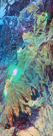
Flight: 07-042-00
Date: 16 Aug 2007
Location: California Fires
Deployment: WSFM 2007
Configuration: Land 2.5 (12-Channel)
Principal Investigators: Ambrosia (CSUMB)
Additional Sensors: None
|
Fire Coverage
Zaca / Tar / Colby / Babcock
|
Data Evaluation
Overall quality is good
|
Processing Information
Level-1B Data in HDF format is available
Flight Line Summary
Spectral Band Configuration
Spectral Response Function Table
Spectral Response Function (text)
|
Browse Imagery
Flight Tracks: 19
Scanlines: 39445
|
Browse Imagery Table
|
Click a Flight Track number to view a quicklook image
Lat/Lon ranges are for the BEG-END scanline nadir pixels
|
Flight
Track |
Time Span
(GMT) |
Heading
(Deg) |
Lat Range
(Deg N) |
Lon Range
(Deg W) |
Length
(Scanlines) |
Altitude
(Meters) |
| 1 |
14:50 - 14:56 |
270.4 |
34.578 - 34.586 |
119.475 - 119.756 |
2401 |
7729 |
| 2 |
14:58 - 15:03 |
96.9 |
34.653 - 34.643 |
119.717 - 119.447 |
2175 |
8100 |
| 3 |
15:06 - 15:13 |
269.9 |
34.713 - 34.731 |
119.466 - 119.792 |
2860 |
8106 |
| 4 |
15:21 - 15:24 |
63.3 |
34.726 - 34.806 |
119.787 - 119.616 |
1545 |
8124 |
| 5 |
15:32 - 15:38 |
269.5 |
34.580 - 34.590 |
119.444 - 119.751 |
2669 |
8114 |
| 6 |
15:41 - 15:46 |
98.7 |
34.649 - 34.640 |
119.727 - 119.438 |
2319 |
8114 |
| 7 |
15:49 - 15:56 |
266.8 |
34.709 - 34.711 |
119.424 - 119.773 |
3081 |
8108 |
| 8 |
16:02 - 16:05 |
46.2 |
34.715 - 34.817 |
119.786 - 119.635 |
1510 |
8112 |
| 9 |
16:36 - 16:39 |
279.5 |
35.940 - 35.965 |
120.227 - 120.336 |
995 |
7435 |
| 10 |
16:43 - 16:45 |
103.1 |
35.962 - 35.946 |
120.349 - 120.216 |
1115 |
7440 |
| 11 |
18:09 - 18:11 |
210.8 |
40.195 - 40.159 |
121.539 - 121.571 |
1000 |
7341 |
| 12 |
18:38 - 18:39 |
211.4 |
40.200 - 40.148 |
121.537 - 121.590 |
859 |
7365 |
| 13 |
19:45 - 19:51 |
183.7 |
37.867 - 37.649 |
119.388 - 119.358 |
2736 |
7434 |
| 14 |
20:04 - 20:10 |
185.3 |
37.906 - 37.652 |
119.399 - 119.397 |
2783 |
7448 |
| 15 |
21:04 - 21:07 |
178.9 |
36.013 - 35.914 |
120.279 - 120.273 |
1000 |
7462 |
| 16 |
21:33 - 21:39 |
227.7 |
34.804 - 34.683 |
119.633 - 119.834 |
2389 |
7456 |
| 17 |
21:39 - 21:47 |
103.8 |
34.661 - 34.642 |
119.826 - 119.451 |
3334 |
7456 |
| 18 |
21:50 - 21:55 |
268.2 |
34.709 - 34.714 |
119.496 - 119.767 |
2474 |
7460 |
| 19 |
22:01 - 22:06 |
92.6 |
34.583 - 34.575 |
119.685 - 119.434 |
2200 |
7459 |
|


